Land sustainability, biodiversity – whatever you want to call it – just hasn’t gotten the attention it deserves compared to climate change.
Why? Because it’s hard to measure.
And even though stakeholders, shareholders, and regulators around the world are starting to take notice of land sustainability as both a massive risk and an opportunity, we still have a long way to go.
You fall into one of two categories.
One, you want to do the right thing. You want to be a responsible and sustainable landowner and contribute to a greener and cleaner earth (which, coincidentally, will keep stakeholders happy, too).
Or two, you operate somewhere like the UK or EU where regulations around biodiversity and the sustainability of land assets are coming into effect.
Either way, you need to know how to actually measure and improve your biodiversity.
You can’t manage what you can’t measure… and that includes biodiversity
Sustainability commitments are much easier to track when they’re assigned global units of measurement. Having metrics to rally around is key to actually creating a plan and reporting on results.
With a universal measurement, local government can influence construction through planning approvals, hold corporations accountable, levy fines, standardize offsets, and more.
But, unlike carbon offsets, which has a standard unit based in math, biodiversity units are more complex.
Biodiversity is, simply put, the amount of life in a given ecosystem. But there are millions of species across the planet, and life is constantly changing between regions, so how do we create a standard metric for that?
Ways to measure your land asset’s biodiversity
The UK has introduced the concept of biodiversity net gain (BNG) and an assessment method based around what’s called the biodiversity metric.
According to local government UK, “Biodiversity net gain (BNG) is an approach to development, and/or land management, that aims to leave the natural environment in a measurably better state than it was beforehand.”
This biodiversity metric is essentially a scorecard that takes into account a few data points to determine an overall BNG score based on biodiversity units. You can then take actions to improve the score of your land assets to promote better land sustainability and biodiversity and to achieve any regulatory requirements.
This biodiversity unit takes into account these core factors:
- Habitat type: The UK government has broadly classified habitats across land, sea water, and freshwater, and gives them an associated biodiversity score.
- Habitat size: The size of a habitat, measured in hectares (or if it’s a small plot, meters squared).
- Habitat quality: A way to rank habitats with an assigned score depending on the quality of the biodiversity in a given area.
- Strategic importance of a habitat: As determined by local authorities
- The connectivity of a habitat: How does a habitat connect with neighboring habitats (eg, grassland next to a highway versus a meadow would have different connectivity).
This metric isn’t perfect. The calculation makes some broad assumptions, and it’s being updated constantly per ecological expert guidance, but it is a step in the right direction.
By taking a macro approach, and factoring in certain leading indicators of micro results, we can classify a habitat’s biodiversity score.
With this scorecard approach, if your company did lessen the biodiversity value of a plot, you could then find nearby low score habitats and transform them into better performing ones, to increase total biodiversity net gain by 10%.
For example, turning modified grassland (pastoral land) into a meadow would take only a few years to mature and would have a large lift in terms of biodiversity net gain.
How to use these biodiversity measurements to make real improvements
Even with the BNG metric, doing this at scale across thousands of hectares or multiple plots throughout a country is difficult.
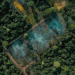
But with remote sensing technologies, like satellites, you can scan and assess all of your land assets at the press of a button, instead of hiring a team of ecologists and waiting months.
But regulators don’t just want measurements, they want action plans and improvements – and it’s likely that these requirements will become commonplace for all organizations.
That’s where AI comes into play. With the right technology and datasets, an AI-powered system can help you create action plans, identify opportunities, accurately measure progress, and report on your SDG commitments.
Want to see this type of AI powered biodiversity tool in action? Contact a specialist today and start hitting your biodiversity goals.