The unexpected advantages of satellite-powered vegetation management
Beyond the expected benefits of employing satellites and AI in utilities’ vegetation management are many real but perhaps hidden benefits.
At its heart, satellite-based vegetation management helps with lessening customer interruptions (CI), reducing costs, increasing grid reliability and resiliency, and establishing data-driven prune plans to improve SAIFI and SAIDI reliability indexes, while ensuring crews are focusing on the right work.
But along with those obvious advantages come many “hidden” benefits in the head office, in the field, in served communities, and with regulators. Let’s take a look.
Looking for a deep dive on satellite-powered vegetation management? Get your copy of our free book today.
Comprehensive data at the desk
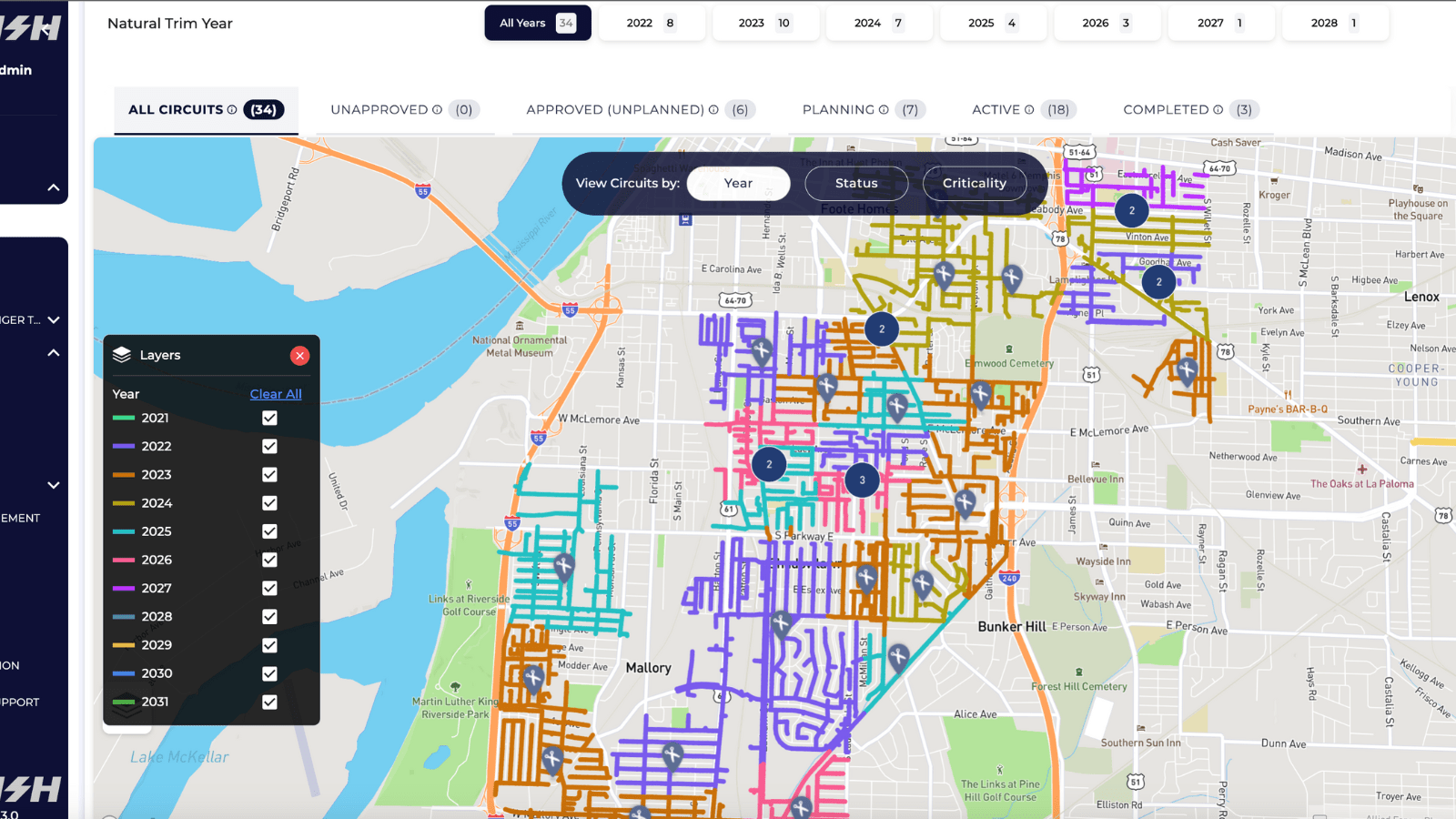
These days, data drives high-performing operations in any business. Most utility vegetation managers have a wealth of right-of-way (ROW) data that flows in from field teams, drones, aircraft, and — for the top-notch managers — from satellites. All this data comes in as photographs, data streams, LiDAR files, GIS location information, written reports, and spreadsheets. And that data is often siloed in separate systems that don’t talk to each other, leaving vegetation managers to piece it all together.
How can anyone make sense of all that data? With great difficulty and a wide margin of error.
Satellite analytics change everything. Vegetation managers now realize far better agility by using all the information the utility already has, including remote sensing data and even enterprise data.
An AI platform automates the data collection process and includes easy connectors from external data sources, integrating the data into comprehensive analysis that yields reliable, accurate conclusions, reports, and recommendations — including historical views and trends.
A view with all the data even helps make budget management more effective. With the right data, vegetation managers can pay for some vegetation work out of the capital budget.
For example, if a utility has thousands of traditional fuses getting replaced by reclosers, the satellite and AI system shows all of them at once. The manager then has the ability to see that a fuse in the middle of a group of trees could be moved upline by 3 spans, still protecting customers but saving potential outages because of the tree density.
In addition, the manager may be able to move some of the related tree trimming costs from operations and maintenance (O&M) to the capital budget during the process, even if it’s only a few hundred spans, that’s money well saved.
More efficiency in the field
By combining satellites and AI, vegetation management gains a new layer of intelligent automation. The system automatically creates work plans within your budget and risk-based recommendations, sending them to managers for approval. This takes countless hours out of assessing, planning, creating work plans, and coordinating with contractors.
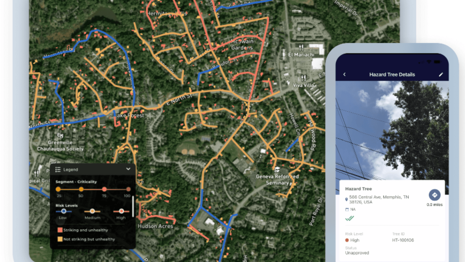
Informative dashboards and reports enhance operational efficiency by offering useful insights at all levels — from executives to field crews. For example, a mobile app is incredibly useful for people in the field, and a performance dashboard has insights an executive or program manager wants to see.
The ability to open a computer and know everything all at once is a game changer. Managers have a bird’s-eye view of their entire network to see exactly what needs to be done to achieve their objectives. It’s a powerful advantage. Better data yields better bids from contractors, more cost-effective work, and efficient, accurate validation of the work.
But safety is perhaps the most important field advantage of satellite technology. The Bureau of Labor Statistics found that tree workers have at least 15 times the fatality rate and 3 times the nonfatal rate of all industries. Satellite systems enhance field safety by identifying difficult terrain, such as swamps, unpaved roads, or steep topographies, and recommending appropriate equipment for the area and the work assignments.
Not to mention that automating most of the pre-inspection process significantly reduces the number of miles driven, cutting down on wasted time by focusing on highest-risk areas, but more importantly, far reducing the chance of a vehicle accident.
Better communication with communities
Satellites and AI help utilities get ahead of community expectations for reliability and environmental sensitivity.
In disaster response, speed is everything. Every hour cut from storm restoration is an hour your community has power. Modern satellite-powered vegetation management helps with this remarkably well.
Just as important is communicating accurate information to the affected communities. With families in the dark and small businesses unable to serve their customers, time slows, and frustrations rise. Alert communities to road closures and downed lines so they aren’t delayed in frustrating traffic and your field teams can work quickly, without unnecessary interference. Give them clear estimates of repair times so they can plan with appropriate expectations. Satellite technology helps all of this.
New abilities in sustainability
Like most businesses, utilities are much more focused on sustainability and environmental responsibility than before. This comes from changing expectations among internal staff, customers, and investors. The efficiency and broad perspectives of satellite-powered vegetation management systems helps with these responsibilities in many ways.
The view from space offers a smaller carbon footprint from operations by reducing the necessity of burning fossil fuels to send teams out for pre- and post-inspections. And fewer miles on the equipment mean that vegetation managers can spread repairs and replacements over longer periods of time.
Satellite tech helps utilities respond to increasing interest of investors in environmental, social, and governance (ESG) results. It’s about the data again. Satellite and AI systems help to establish, track, and report on ESG metrics to help utilities track and meet their sustainability goals, to show results to management, regulators, and local communities.
In addition, utilities may be able to use their own land for carbon offsets as they pursue their sustainability commitments. With the cost of carbon credits projected to rise by up to 3,000% by 2029, organizations can now save up to 90% on carbon offset programs by unlocking their own land assets. Large landowning businesses such as utilities have an important opportunity here. If utilities dedicate 10% of owned land to carbon capture, they could save almost £300 million by 2035.
To learn how other utilities are achieving success with AiDASH Intelligent Vegetation Management System, view our case studies here.