11 questions to find the right satellite-powered vegetation management tool for you
Investing in new technology is never an easy decision, and 70% of the time those digital projects fail. Which can be chalked up to a lack of buy-in, poor integrations and a lot of overpromising and under delivering on the sales side.
But with climate change, rising costs, and more scrutiny on providing reliable power now than ever before, you must invest in technology.
But, like anything else, not all satellite-powered vegetation management tools are created equal.
We’ve heard the horror stories of pilots going bad, deadlines being missed, capabilities being oversold and underdelivering.
To help make sure that never happens to you again, we’ve put together this list to give you the right questions to ask to cut through the fluff and make sure you end up with the right fit.
1. How quick from signing a contract to getting actionable data?
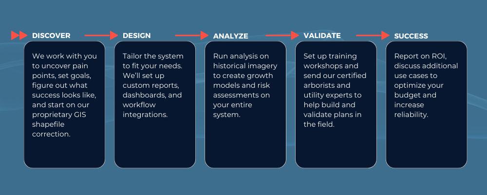
This is a decision that you’ll have to make. It can take months to implement certain tools and onboard. Others are much quicker: for example, at AiDASH we often can get you up and running in as little as 8 weeks, making that return on investment (ROI) period much quicker.
2. What’s an example of actionable insights I’ll get?
Any good satellite-powered vegetation management tool must be actionable. Just getting a scan and being told “you should send a crew to check out this problem area” isn’t actionable.
You likely know a lot of your problem areas. You need to uncover insights and truly be able to perfect your program.
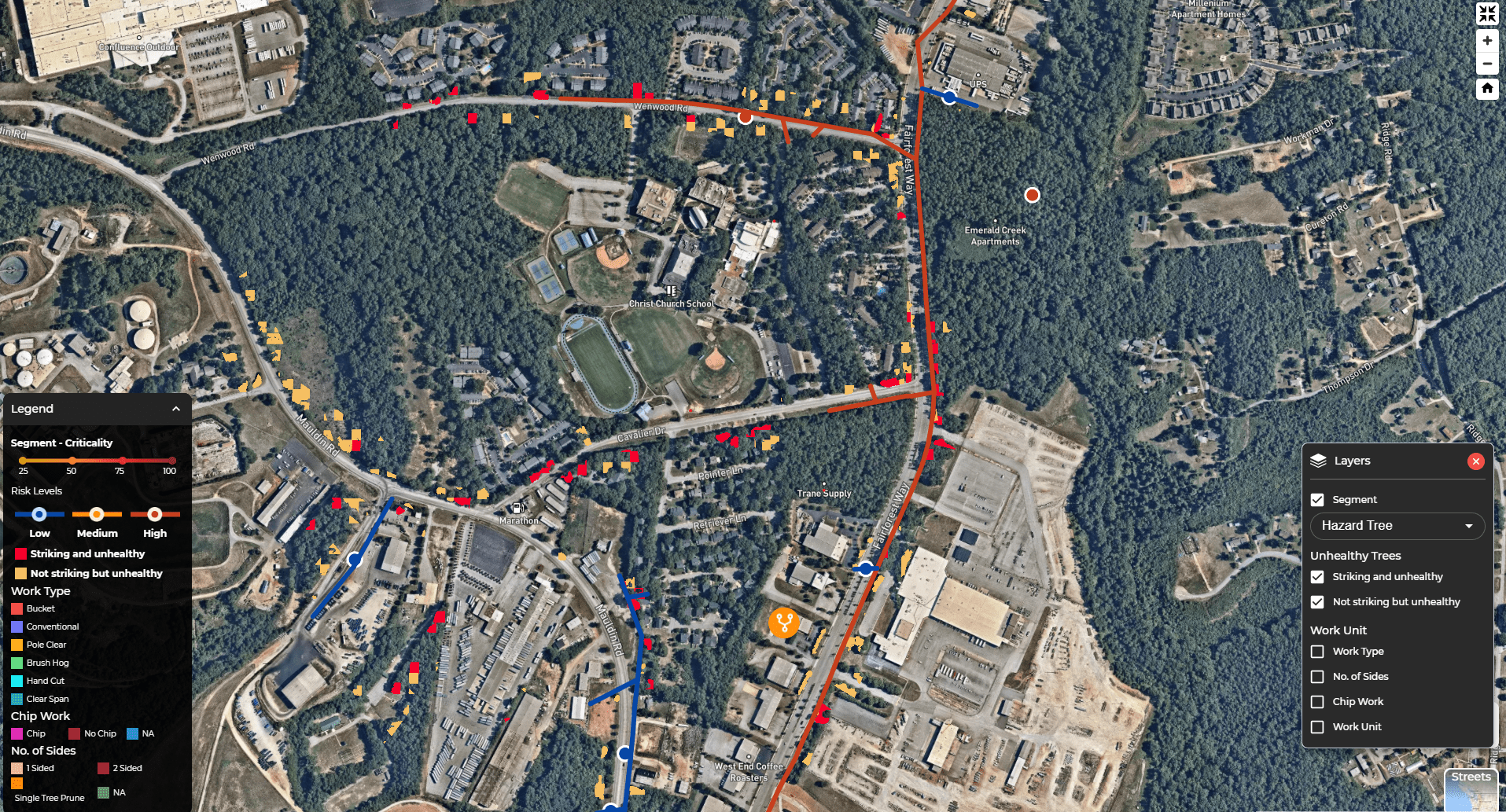
For instance, you should be able to plug in your budget and get a list of priorities based on reliability and risk impact. Or get a list of your top 100 high risk trees in a given area so you can point crews exactly where to inspect, not just the first 100 trees they see in that area.
Check out this list of must-have features your satellite-powered vegetation management tool needs.
3. What’s your revisit rate? How often can I scan my system?
The revisit rate of satellites today is extremely fast, but that doesn’t mean that’s how often you can actually scan your system. Be careful here. You need to dig into how often you can scan your system, and what the vendor recommends.
At AiDASH we recommend starting with twice a year, once right after leaf out, and once right before the end of growing season. We can then add on scans for disaster response or other special programs as needed but starting with twice a year is the best cost-to-value ratio at the start.
4. Can you currently support asset inspection?
Some vendors claim this is possible today. It isn’t — at least not without extremely high cost. Only a handful of commercial satellites with the resolution to perform asset inspection are available, so it is a costly and time-consuming process to get that imagery. The good news is that by the end of 2023, a brand-new constellation of hyper-spectral satellites is being launched, which unlocks a ton of new use cases, including asset inspection.
5. How accurate are the models?
A satellite-powered vegetation management tool is only as good as its AI models. It takes a lot of data to train a model, so naturally the prediction rates will improve over time. Ideally you want to get at least 80% alignment between satellites and the field, but if you can get closer to 90%, you’ll gain even more value.
AiDASH has over 80 current customers, with our models deployed on 500K+ T&D miles, which makes our models extremely accurate, oftentimes higher than 90% alignment.
6. Do you offer GIS shapefile correction? How?
The quickest way for an unsuccessful satellite project is to work with an inaccurate GIS shapefile. Otherwise, you’ll never have a correct read on vegetation distance from the conductor.
A lot of vendors claim they have a solution for this, but few actually do. Try and get specifics on this if you can. If you can’t (some processes are proprietary, like ours), ask to speak to a customer to get a reference on accuracy.
7. How will this fit into my daily workflow?
Every utility’s day-to-day looks a little bit different. You have different processes, you use different tools, you need to report a little bit differently. Really try and dig in to see how a new satellite solution fits into this. Will there be capabilities that overlap with other tools that you could get rid of, or maybe there’s another tool you need to be able to integrate with.
At AiDASH we often do “day in the life” walkthroughs with former vegetation program managers on our staff to help you understand if it is a good fit for your utility.
8. Will I be able to incorporate LiDAR data or other on-the-ground sensors?
Many utilities get data from multiple places, whether it’s LiDAR, sensors, or just manual inspection recordings. A good satellite solution will help to automate the data collection process, but it should also have a way to easily plug in these external data sources into the model to make even more accurate predictions.
9. What types of reports and dashboards are available out-of-the-box?
There should be dashboards, reports, and insights that are useful at all levels, from executives down to the field crews. For example, a mobile app is incredibly useful for people in the field, and a performance dashboard will have insights an executive or program manager wants to see.
Make sure to think through every possible use case to see if the tool can offer the type of reports you’ll need.
10. Do you have a way to monitor tree health or support disaster management capabilities?
Recent advancements have unlocked tree health monitoring to proactively identify, categorize, and mitigate hazard trees before the cause outages. This feature should be at the top of any must-have list.
To go along with that, capabilities that support disaster management – pre-storm grid hardening, during the storm resource staging, and post storm restoration – are incredibly important, especially if you operate in an area of wildfire risk, coastal storms, or sever winters.
11. Can I talk to a current customer?
If you can’t speak to a customer for a reference, it means the vendor either doesn’t have happy customers, or is exaggerating capabilities when talking to you. Either way it’s a problem. Whenever you’re in doubt, ask for a reference, a good vendor will be happy to provide one.
We hope this list will come in handy when you’re evaluating satellite-powered vegetation management vendors. Picking the right one can be transformative for your vegetation program, and if you’re still on the fence, you can always ask to do a pilot with your top vendor.
Want to see for yourself how we’ve helped over 80 utilities increase reliability by over 10% while saving 20% of their vegetation management budgets? Talk to an expert to learn more.