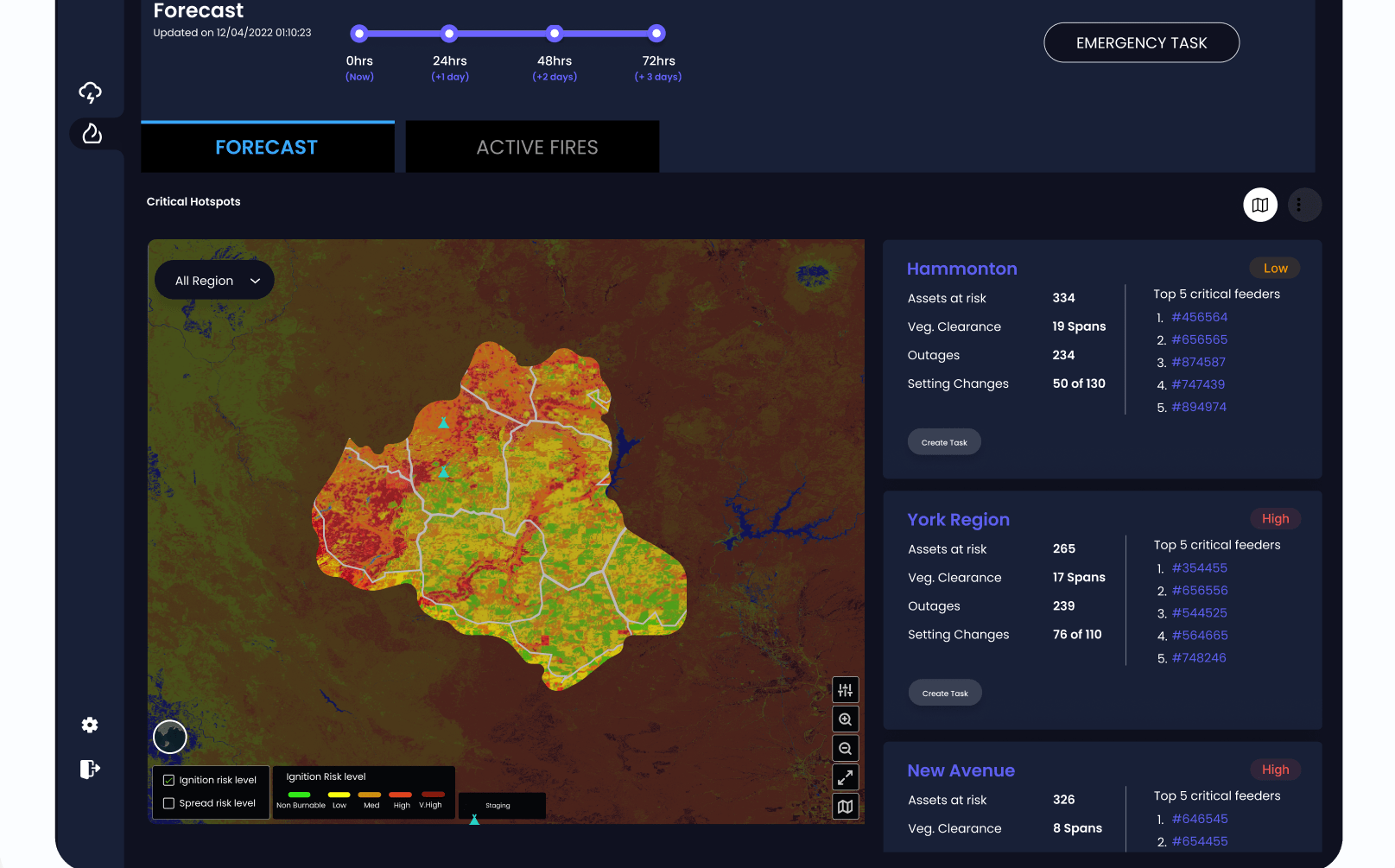
CRIS WildfireTM

The Prevention-first Approach to Wildfire Risk Mitigation.

CRIS Wildfire™ gives utilities the insight they need to prevent the next ignition — not just respond to it. By combining vegetation intelligence, real-time weather, and infrastructure data, CRIS Wildfire pinpoints high-risk locations and provides clear, actionable steps for mitigation. The result is a wildfire strategy that is predictive, precise, and prevention-first.

Get a Demo

News Flash: AiDASH Unveils CRIS™ 2.0 to Help Utilities Prevent Wildfires Before They Ignite. Learn More!

More than 135 utilities of all sizes across the globe use AiDASH climate technology

72-hour
advance notice to execute emergency wildfire responses 
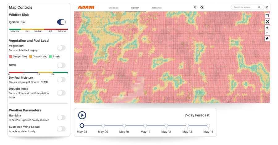
Faster Icon
1-6-hour
refresh for wildfire & storm risk predictions
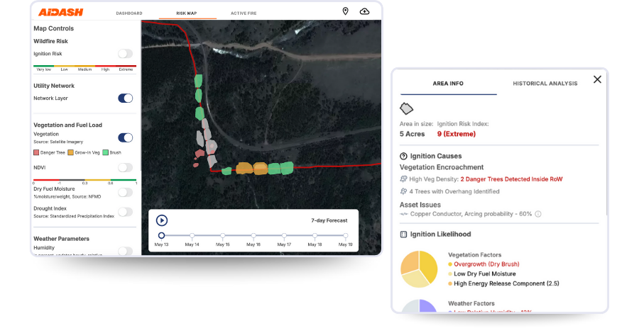
accuracy
24/7
active fire & weather watch
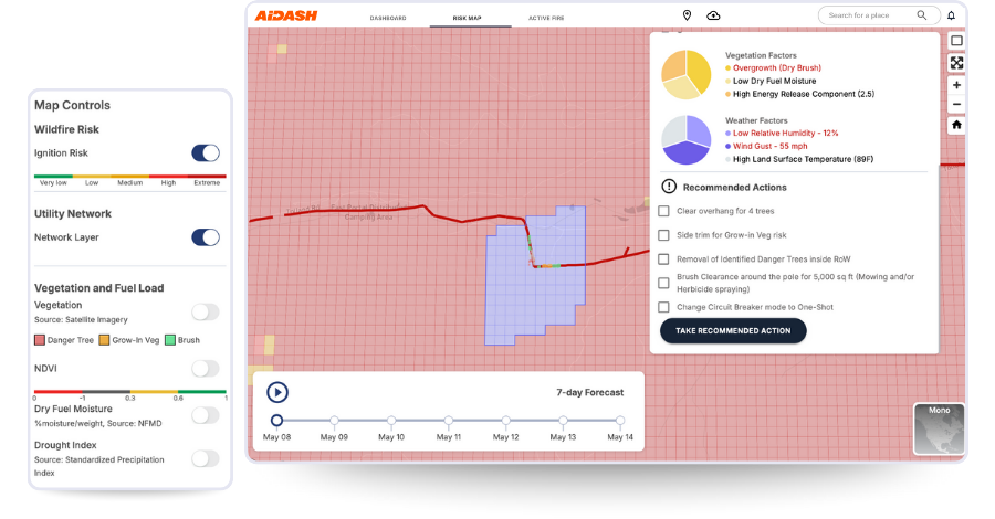
World Map

Ignition Risk Mapping

See where fire risk starts.

  • Identify ignition hotspots where vegetation, weather, and asset vulnerabilities converge
  • Monitor risk across your entire network with continuous updates
  • Prioritize areas that pose the greatest threat to people and infrastructure
play

Disaster Talks: How to prevent wildfires for electric utilit...

Watch the Interview

play

Disaster Talks: How to prevent wildfires for electric utilities

Watch the Interview

Vegetation Connectivity Analysis

Disrupt the fuel. Stop the fire.

  • Analyze where vegetation provides uninterrupted fuel pathways
  • Recommend areas for defensible space and natural firebreaks
  • Reduce the chance of small ignitions becoming large, uncontrollable fires
webinar

Wildfire and risk mitigation using satellite analytics: Avi...

See Webinar

webinar

Wildfire and risk mitigation using satellite analytics: Avista's journey

See Webinar

Dynamic Weather and Fuel Modeling

Forecast the fire before it spreads.

  1. Integrate real-time weather and wind data with live fuel moisture readings
  2. Predict how and where a fire could travel hour by hour
  3. Support emergency planning with timely, location-specific intelligence

Synthetic aperture radar: The hero tool for remote sensing...

See the Blog

Synthetic aperture radar: The hero tool for remote sensing

See the Blog

Targeted Mitigation Recommendations

Act with clarity, not guesswork.

  • Receive AI-driven guidance on where and what to trim, remove, or disrupt
  • Align mitigation work with risk, asset importance, and community exposure
  • Maximize the impact of every dollar spent on fire prevention

Disaster Talks: Going from hurricane to power on, faster...

Watch the Interview

Disaster Talks: Going from hurricane to power on, faster

Watch the Interview

Active Spread Predictions

See how a fire will spread and forecast impact on the network.

  • Predict Wildfire Spread using AI and satellite data for real-time risk insights.
  • Model Fire Paths with advanced simulations to forecast spread direction.
  • Guide Rapid Response by identifying high-risk zones for quick action.
electric-utility

Electric utilities are experiencing greater regulatory inves...

electric-utility

Electric utilities are experiencing greater regulatory investigations over outages and wildfires.

Integrated Response Planning

One view. All teams. Faster action.

  • Share a unified, live risk view across vegetation, emergency, and operations teams
  • Coordinate work from control room to field with shared insights
  • Improve response time and consistency when seconds count
Integrated Response Planning