Tech FAQ: What inputs does CRIS use to predict incidents, customer interruptions, and resource allocation?
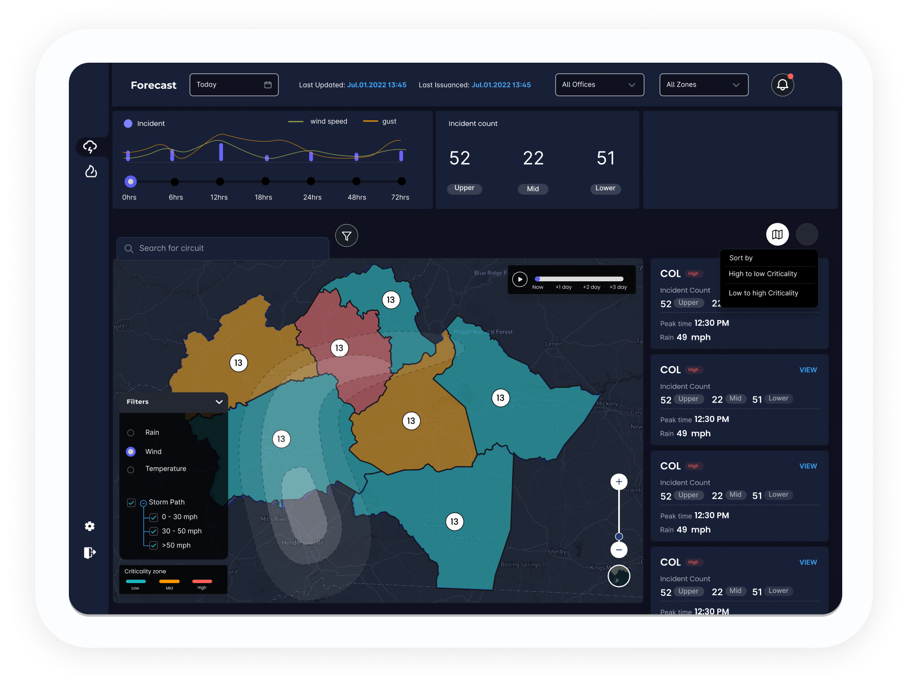
What is CRIS?“CRIS” is the AiDASH Climate Risk Intelligence System™. It helps utilities and other organizations predict storm and wildfire incidents and outages in advance, restore safely, communicate accurately, and build climate resilience.
Things to know
This AI-powered system fuses satellite imagery, real-time weather data, vegetation data, and historic outage and resource usage data to give you insights before, during, and after a major weather event.
The technology now makes it possible to predict damage from extreme events to allow utilities to:
- Prepare and place resources.
- Evaluate the damage to understand what restoration is needed.
- Determine which sites are accessible.
- Help plan the restoration itself.
While other AiDASH products are used for routine operations and maintenance in core industries, CRIS is for emergency management at scale.
If your organization already uses AiDASH Intelligent Vegetation Management System™ (IVMS), you can use CRIS for your storm management programs.
CRIS predicts incidents, not outages. That is, it can predict what assets will be impacted by weather events. From there, you can determine how many downstream customers may be affected.
The quality of the results depends on the amount and quality of data your utility provides, because a huge part of CRIS’ ability to predict incidents and restoration depends on knowing about your assets, unique geographical challenges, customers’ resources, and more.
Types of inputs
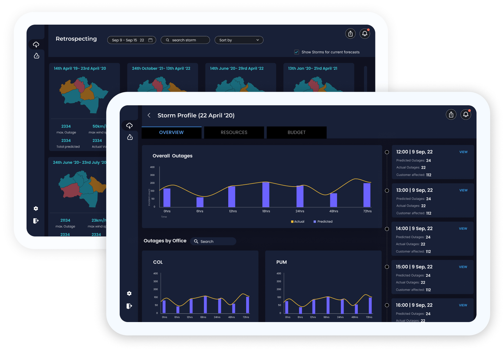
Historical weather data. AiDASH weather data for the entire U.S. from the past 20 years. At the end of every month, AiDASH gets fresh data from vendors and fold that in with the rest of the data. (That means each month, our AI model continues to improve.)
Historical outage data. AiDASH also gets historical outage data from each utility and uses it to improve the AI model.
Current asset data. This data is crucial to making CRIS work optimally. This is data that your utility provides. It includes your geospatial data, the number and location of your poles and conductors, the install years of your assets, the materials you used, what physical offices you have (and what human resources are available at those offices), and more. The greater the quality and quantity of this data, the better CRIS will work for you.
Live weather feed. This tells AiDASH what weather incidents are coming in the next 72 hours and where each is forecast to go. Like historical weather and outage data, AiDASH gets live weather feeds from vendors. These vendors specialize in capturing live weather data from satellites and their own weather stations. The data gets refreshed 4 times each day.
These vendors process this data and partner with AiDASH to acquire their data for analysis. AiDASH relies on multiple vendors (usually 3-4) at the same time. This increases the strength of the model.
Vegetation data. This is AiDASH’s own satellite imagery, which is used in conjunction with LiDAR (both publicly available LiDAR and your utility’s LiDAR scans), to power IVMS. AiDASH uses your shapefiles and compares them to this vegetation data to determine where your assets are susceptible and vulnerable to storms and wildfires.
Miscellaneous. Essentially, AiDASH can ingest any data you have and fuse it with the rest of the data to create more accurate predictions.
How it works
CRIS takes in the above data and feeds it to the AI model. The model’s output gives AiDASH a picture of where susceptibility is at a given point in time. That lets AiDASH offer you predictions that help you both prepare and deploy ahead of weather events and monitor and survey after events so you can restore services faster.
Click here for more information about our Climate Risk Intelligence System™ (CRIS).