- Learning Center
- Blogs
- Securing tomorrow’s grid: How space technology and AI are transforming utility operations and reliability
Securing tomorrow’s grid: How space technology and AI are transforming utility operations and reliability
This is a recap of a session from AiDASH Evolve 2024
Summary:
- Very high-resolution satellite imagery, collected by Maxar Intelligence, provides a detailed view of Earth’s critical infrastructure. With 30 cm-class clarity and frequent updates, Maxar’s constellation of satellites monitors everything from environmental changes to disaster impacts, enabling faster, data-driven decision-making.
- AiDASH turns data into targeted action. By fusing enterprise client data, the SatelliteVision™ pipeline, and geospatial inputs with AI, AiDASH’s tools help utility companies manage vegetation, predict storm and wildfire risks, and enhance their resilience.
- Together, Maxar and AiDASH deliver monitoring solutions that combine satellite imagery with AI-powered analysis, enhancing grid reliability by swiftly identifying emerging risks and keeping assets secure.
High above Earth’s surface, a new generation of satellites is recording more than just breathtaking images — they’re unlocking critical insights to secure tomorrow’s grid. At AiDASH Evolve 2024 in New Orleans, experts from Maxar Intelligence and AiDASH demonstrated how satellite technology and AI-driven platforms are reshaping infrastructure management and enhancing response strategies.
On stage, Josh Winer, Maxar’s Senior Director of Enterprise Sales, and Rahul Saxena, AiDASH’s Chief Product and Technology Officer, shared real-world examples of how very high-resolution imagery and advanced AI are changing the way utilities approach complex challenges that historically required boots on the ground.
By combining Maxar’s unmatched satellite clarity with AiDASH’s targeted analytics, it becomes possible to monitor assets; anticipate threats; and make informed, proactive decisions that keep communities safer and operations more resilient.
The power of detail in Maxar’s satellite imagery
Maxar’s satellites offer an unprecedented view of Earth, capturing over 5 million square kilometers of very high-resolution imagery daily — enough to cover an area the size of India. All that data feeds into a massive library that dates back to 1999, with an emphasis on cities, industrial sites, and ecologically sensitive zones. Once all of Maxar’s fleet of next-generation WorldView Legion satellites are operational in early 2025, it’ll be capable of revisiting some of those high-priority areas up to 15 times per day.
Winer shared several examples of what WorldView Legion’s 30-centimeter resolution can do now. One application involved measuring the capacity of oil tanks in Singapore based on the shadows cast by their floating tops. Using volumetric analysis on these types of storage facilities, it becomes possible to predict what oil reserves look like around the world.
Maxar’s capabilities extend beyond natural color images. The satellites capture near-infrared and shortwave infrared data, detecting details that would otherwise be invisible to the naked eye. For instance, near-infrared imagery can assess vegetation health during wildfires, as Winer illustrated with imagery of California’s Dixie-Jumbo fire. Meanwhile, shortwave infrared can penetrate smoke to reveal active fire hotspots
AiDASH transforms satellite data into targeted action
An increasing number of satellites equipped with higher-resolution sensors are but one of the technological advances making it possible to secure critical infrastructure more effectively, according to AiDASH’s Rahul Saxena.
Analyzing all that data also requires massive processing horsepower. Case in point: Training Google AI’s Minerva quantitative reasoning model in 2022 required 2.7 billion petaflops of compute. And the types of multimodal models in use today for vision-oriented analysis like AiDASH’s are even more sophisticated.
To that end, AiDASH integrates Maxar’s imagery with custom-built AI models designed for critical infrastructure industries (utilities, construction, land management, and water). This approach allows each segment to monitor and manage its assets with precision, even over large and complex networks.
The AiDASH Full Stack Platform for Grid Inspection and Monitoring™ ingests all the imagery fed from Maxar’s constellation and fuses it with client-specific data to generate actionable guidance. For a utility, that could include network and connectivity information, outage history, customer count, and maintenance specifications. A construction company might have land and ground survey data to integrate. And a wastewater facility would add historical data and biodiversity net gain specs.
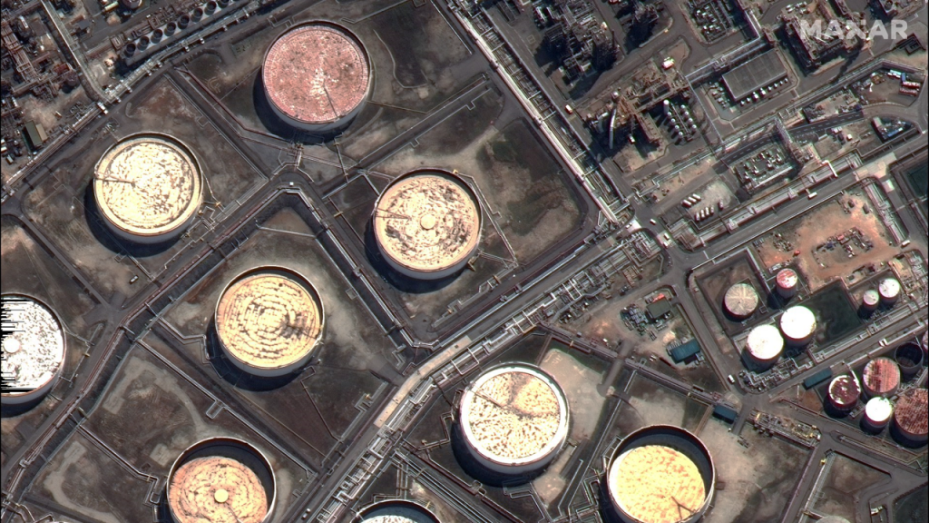
There’s a lot of complexity in what AiDASH calls its SatelliteVision™ end-to-end pipeline, too. At one end, the company acquires, stores, and optimizes the data for areas of interest. That information can take many forms, like multispectral, hyperspectral, synthetic aperture radar (SAR), thermal, or infrared. Quality checks and imputations are performed on the data to make sure its outputs are useful, at which point AiDASH’s AI algorithms get to work generating core features, such as semantic segmentation, object detection, change detection, and different types of classifications.
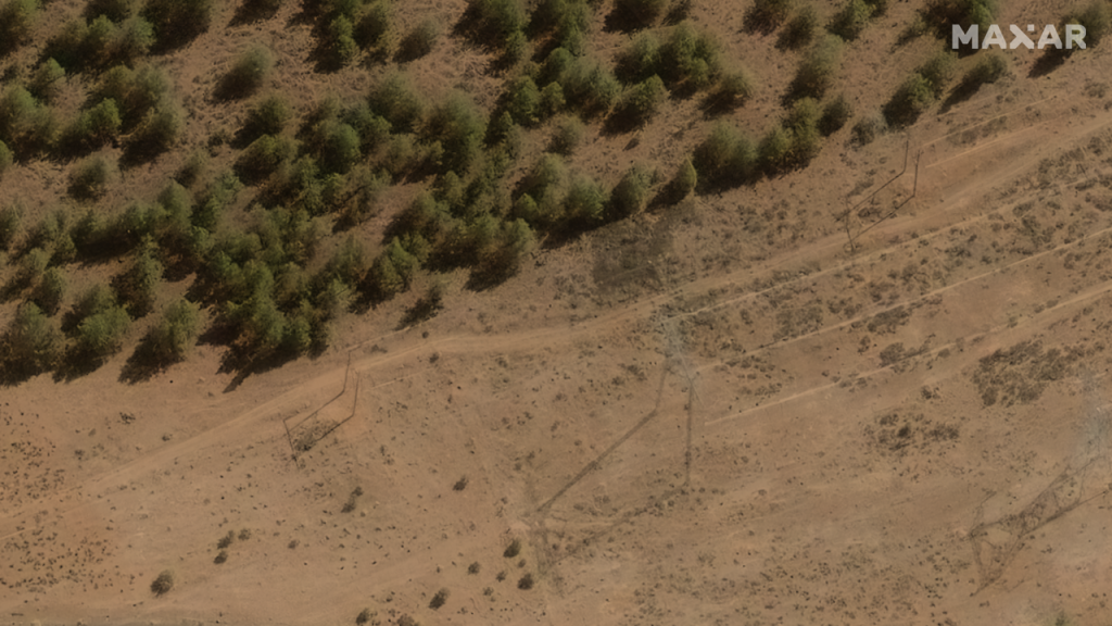
One of the most practical applications of this technology is VegetationAI™, an AI model designed to help utilities detect and respond to potential threats like vegetation encroachment, storm risks, and wildfire hazards. VegetationAI™ highlights areas where vegetation may endanger transmission lines, pipelines, or other critical assets, allowing for precise maintenance planning without the need for extensive fieldwork.
Securing the future of utility operations with space technology and AI
Maxar is poised to push the boundaries of satellite imagery technology, enhancing tomorrow’s grid with more coverage and unmatched collection capacity. AiDASH plans to leverage those advancements by taking a unified approach to grid inspection and monitoring.
It starts with a satellite-first full network scan, followed by need-based partial-network scans for various use cases.
In the future, environmental data, folded in with utility data, will inform the AiDASH Platform to identify the types of information needed to optimize utility operations. It will give customers insights into key factors like vegetation and terrain and road accessibility. And instead of simply identifying poles from space, for example, it will be possible to flag damaged poles, tilted poles, and rusted poles using a combination of drones and other aerial imagery, vehicle-mounted sensors, and LiDAR.
This proactive approach means fewer outages and safer, smarter operations. AiDASH’s models, customized to accommodate each company’s specific data and needs, help teams make informed decisions about where to allocate resources, thereby minimizing field visits and reducing OpEx.
Whether planning for extreme weather, assessing wildfire risks, or scheduling essential maintenance, this technology partnership between Maxar and AiDASH offers a streamlined, data-driven way to secure the grid in the face of growing challenges.
Check out more sessions and information from Evolve 2024, and reach out to see the AiDASH Platform in action!
The best collection of tools, tips, guides, and industry stories – straight to your inbox.
Subscribe to our newsletter