Satellite-powered vegetation management vs. LiDAR
LiDAR is great for one off scans and asset inspection. But when it comes to vegetation management, continuous network monitoring, risk-based assessments, and mapping your budget to reliability improvements, it’s a different story.
Overview of AiDASH (satellites) and LiDAR
You have plenty of options when it comes to remote sensing, but satellites and LiDAR draw the most comparisons.
Both are going to give you a lot of data, which is key to an optimized vegetation management program. However, how they do it, the format of that data, and what decisions you can make with them, are very different.
This page breaks down each so you can understand the differences and make the best decision to drive your program forward.
High-level overview: AiDASH
AiDASH is a climate tech company that uses satellites and AI to streamline vegetation management for over 135 utilities.
Satellites make accurately scanning entire T&D networks possible with the click of a button.
With our AI, these scans become actionable insights and work plans. This gives you a view of high-risk areas, budget optimization, tree health, growth rates, and more — along with recommendations to make sure every dollar spent maps back to reliability improvements. And it’s all within a single, easy-to-use solution.
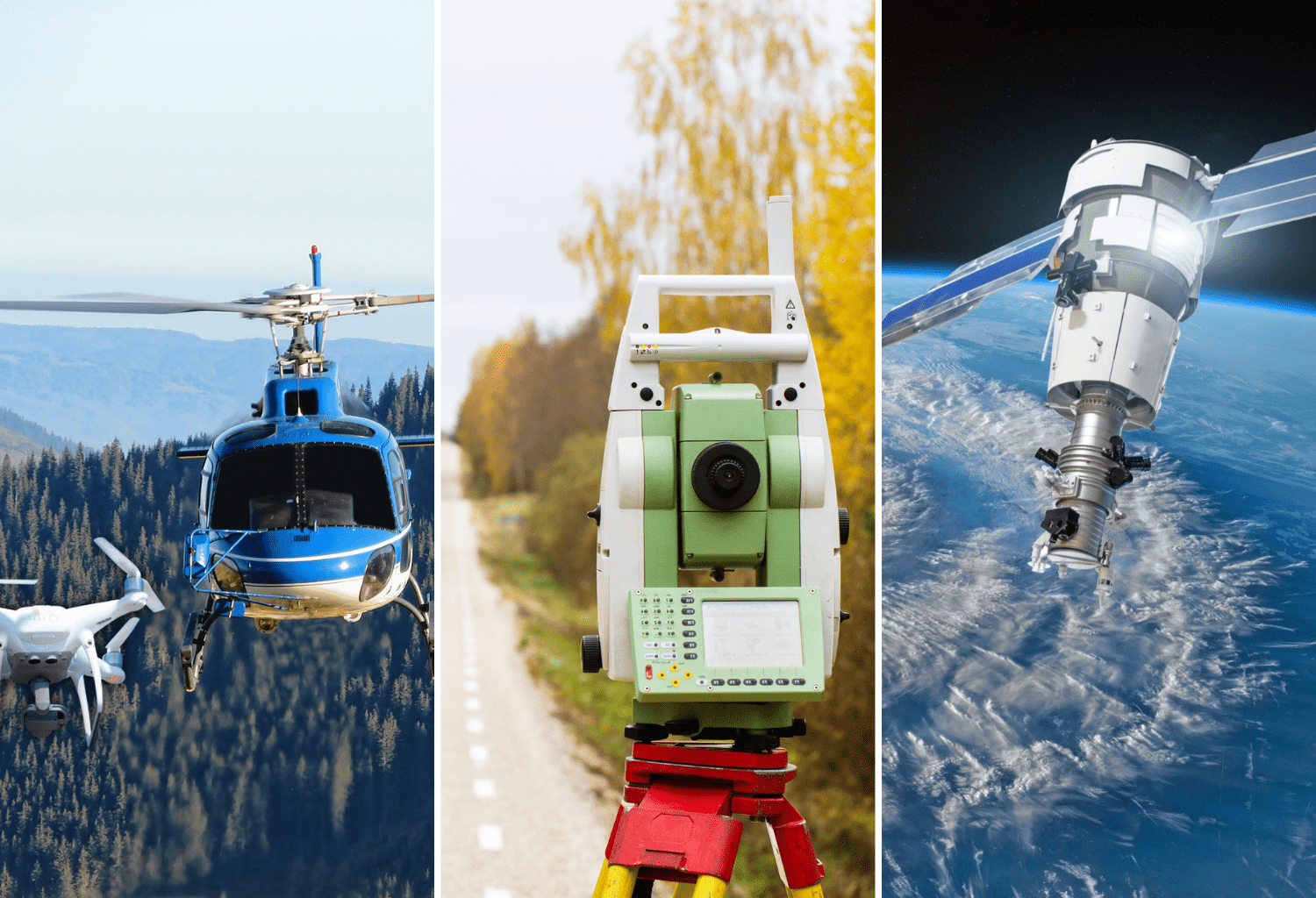
High-level overview: LiDAR
LiDAR comes in a few forms: ground based (walking or driving) and aerial. In aerial the most common approaches are with fixed-wing aircraft, and helicopters, but some utilities may opt to use drones in certain situations.
LiDAR provides very accurate scans, great for asset inspection, but for vegetation management it isn’t viable to use at scale.
One vegetation program manager said “With LiDAR, you get a one off, 2D snapshot. It’s really difficult to make forward thinking decisions off that, and to scan multiple times within a year would blow the budget”.
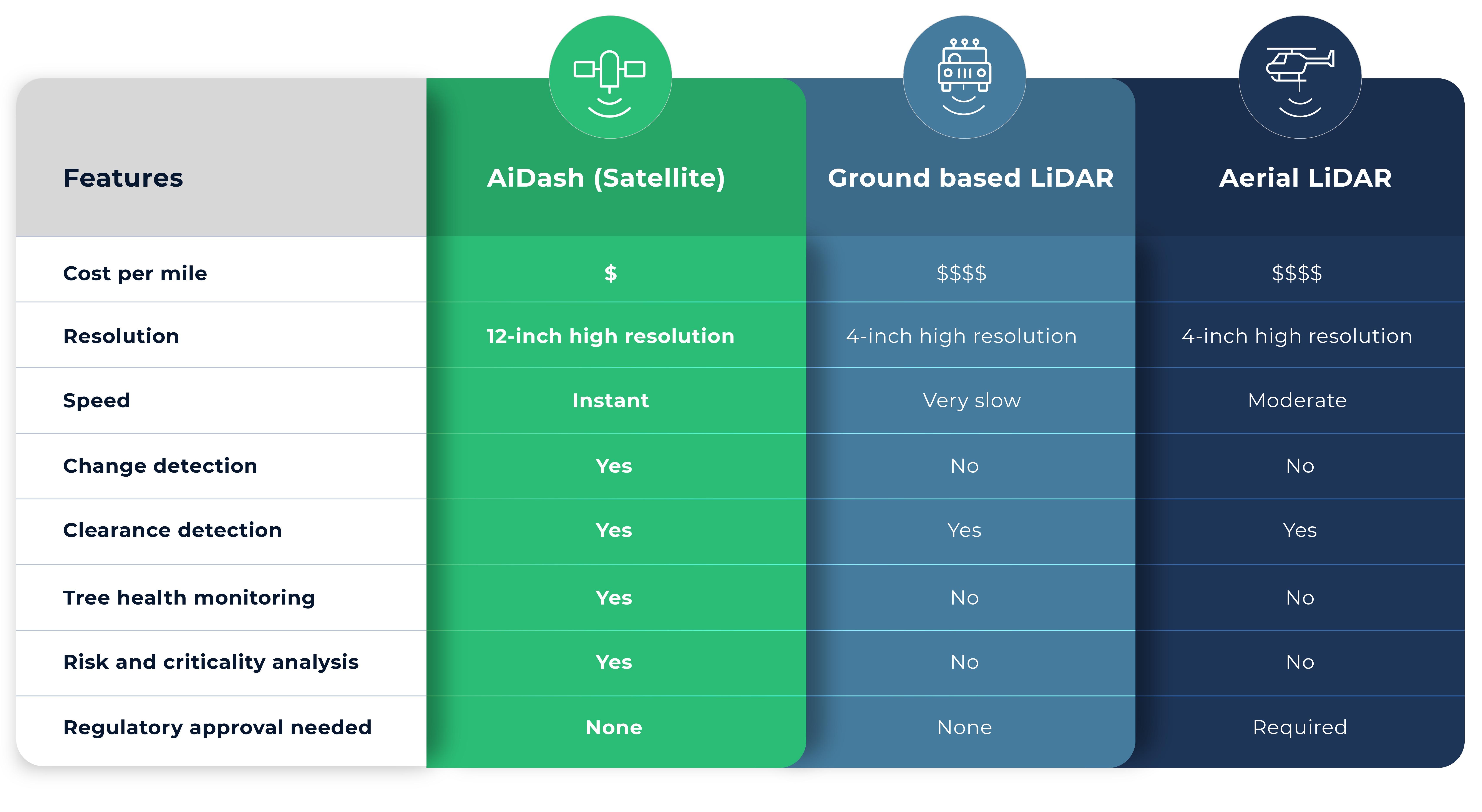
AiDASH vs. LiDAR: Pricing comparison
LiDAR costs can vary with the method used, but generally, even the least expensive form of LiDAR is 5x what AiDASH costs.
One AiDASH customer said:
LiDAR requires someone in the field to complete the scans, whether that’s driving a truck or flying. There are UAVs but sending those up is incredibly costly. This is before any data analysis which has to be done after each scan, or factoring in the carbon emissions, regulatory permissions, and safety concerns.
Satellite-powered vegetation management on the other hand doesn’t require a person to scan, regulatory approval to fly, or release any carbon emissions. Plus, AiDASH takes care of all data analysis.
AiDASH vs. LiDAR: Head-to-head capabilities
Satellites can monitor factors like tree health, chlorophyl content, moisture and soil conditions to identify hazard trees and wildfire risk, as they start to decline, not after they’re dead. This type of proactive monitoring can’t be done with any other technology.
One vegetation manager put it like this, “LiDAR is great information, but it’s stagnant. It’s just a scan in time and it doesn’t change. Day one, after you scan, everything becomes assumptions, and to rescan often enough to make real business decisions just isn’t in the budget”. Satellites have been in orbit for over 50 years, giving access to years of historical data and it is cost effective to scan multiple times a year for change detection.
With AiDASH and satellites you can get a scan of your entire system with one click, constantly updated with constantly updated with new risk and reliability analysis. Because of that many utilities are opting for continuous monitoring with satellites and sending LiDAR on certain sections based on those findings.
LiDAR is 4 inch resolution, satellites are at 12 inch, which is the same accuracy as an on the ground inspection. LiDAR is great when you need to do a small section and get things down to the inch, like with asset inspection, but may not be in your budget for vegetation management. Satellites are a cost-effective way to monitor your entire network for clearances, mitigate potential disasters, and optimize your cycle plans based on risk and reliability. Plus, satellites are expected to be at 4inch resolution by the end of 2023, making it a future proof technology.
LiDAR is great for scanning a section on a clear day, but it can’t see at night, through clouds, or during storms. Satellites use Synthetic Aperture Radar (SAR) to pierce through cloud cover and see at night, which makes it particularly useful during disaster management and restoration.
Regulatory approval is a factor to consider with aerial LiDAR, as many local governments have ordinances and regulations that can prevent or slow scans. Satellites are readily available without requiring any regulatory approval to capture imagery.
Remote sensing isn’t just about acquisition costs. Following LiDAR scans, the data must be processed by analysts to get meaningful insights. AiDASH uses AI to run powerful analysis, create workflows, and provide insights to make meaningful business decisions quickly.
LiDAR data is extremely accurate, and it certainly has its uses for utilities. The cost and “snapshot in time” nature just make it difficult to justify for vegetation management. The good news? If you have LiDAR data already, we can input that into our AI models and combine it with our satellite data to give you even more accurate predictions.
AiDASH is trusted by more than 135 utilities of all sizes
“LiDAR information is great, but it’s just a scan in time. It doesn’t change. To rescan our system was going to be very costly, whereas AiDASH fit into our budget; I feel like we’ve been making better decisions, and the reliability numbers speak for themselves.”
“This ability to image our entire system is a game changer. Think about that. You can know everything, all at once. That is incredibly powerful. And that, in the vegetation management world, just has not been the case up until this technology.”
“AiDASH takes a satellite image of our entire system all at once. They focus on growth rate, criticality, and hotspots that may be on our system. Our personnel can look at this output and know exactly where we need to focus our resources in the right way.”
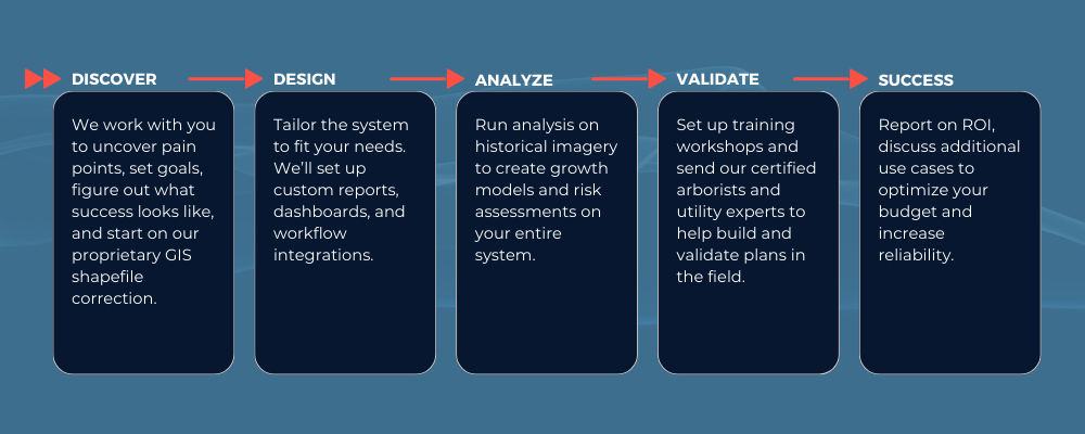
Getting started with AiDASH
With a team dedicated to your success, you can move confidently to data–driven, satellite-powered vegetation management.
Get your own live demo
Now that you’ve done your research, want to see the solution for yourself?