Blogs

Remote Monitoring and Survey of Distributed Assets

AiDash

Monitor critical infrastructure, assign tasks, and track progress from a central dashboard

An end-to-end remote monitoring system built for field workers and supervisors

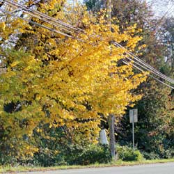
Vegetation hazards, RoW encroachments, wildfire risks and weather-related damage are the major operations and maintenance concerns for power utilities. Imagine the capability to have complete visibility of hazard locations via a web dashboard and mobile app.Built for field workers and supervisors, our satellite-powered Remote Monitoring and Survey System (RMSS) gives stakeholders the control they need for proactive and preventive operations and maintenance. Let’s understand.

Unlock the potential of structured data & automate decision-making

Experience the convenience of having absolute information about vegetation and RoW risks along your distributed assets, on a feeder, tower or pipeline-level. AiDash Remote Monitoring and Survey System brings you a powerful dashboard at your command with the following features:

30-centimetre VHR Satellite Imagery

Keep an eye out for maintenance and repairs of distributed assets across geographical locations remotely with our multispectral satellite imagery. Our 30-cm Very High Resolution Satellite Imagery has the ability to detect small objects with extensive detail and accuracy.

Accurate asset map correction

Our Deep Neural Network systems assess satellite imagery to provide you with a one-time, accurate asset map index. It can also detect anomalies with your current map and rectify it in the process. Rely on our AI model to help your field workforce make informed decisions for asset operations and maintenance.

Proactive hazard detection

Our AI model can detect any encroachment or hazard easily with the help of our VHR satellite imagery. For instance, vegetation encroachment near powerlines, snow accumulation along Right of Way, Encroachment & construction around Oil & Gas pipelines and the like. On hazard detection, it can identify the geolocation, alert the assigned field force by creating a new task with immediate effect.

Routine inspection via satellite

Having AiDash Remote Monitoring and Survey model at your disposal will keep you on top of the game at all times. There’s no need to perform routine inspections using age-old approaches such as line patrol or on-site patrol or expensive and slow aerial surveys. Satellites can inspect an entire network of assets on-demand in less than a day allowing complete visibility of assets at all times, and thereby, helping industries save big on operational costs.

Take your asset maintenance operations to the next level

  • Monitor and inspect assets from anywhere
    No matter where you are, keep a close eye on your assets.
  • Reduce operational costs
    From resource allocation to operations, save big on costs
  • Minimize risk of human errors
    Drive high-quality efficiency as Artificial Intelligence helps you automate decision making.
  • Gain complete visibility
    Discover data-driven insights that aid better business outcomes.
  • Information at your fingertips
    Gain complete control over assets spread across geolocation on a unified, powerful dashboard.
  • Change detection & analysis
    Identify change based on historical data and analyze assets operations and insights efficiently.